
The NZ Transport Agency (NZTA) has come a long way. When Transit NZ (motorway builders) merged with the LTSA (Land Transport Safety Authority) to form the NZTA back in 2008, it was pretty clear the motorway builders were still in control, and consideration for public transport, walking and cycling was far from their minds. Times have changed over the last seven years, although you still see vestiges of the old guard down in Wellington trying to construct a monstrous flyover around the Basin Reserve.
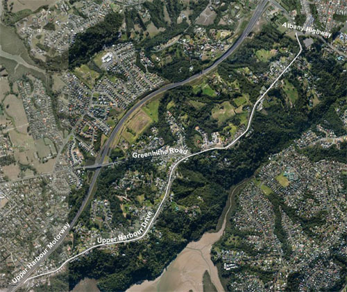
We have a much more enlightened NZTA team in Auckland. The motorway builders are still at it of course, in this case connecting up the Western Ring Route with SH1 at SH18/Constellation Drive on Auckland’s North Shore. But they’ve come to realise there’s more to the “Transport” in their name than cars and trucks – in fact you’ll even see a whole section of their website devoted to PT, walking & cycling. The realisation that cycling is now a valid transport mode with the potential to relieve congestion by switching mode share is now well and truly acknowledged.
We first met with the NZTA team to discuss the Northern Corridor back in December last year. We had a few simple pleas for them then:
- Please can we share the corridor ALONG the motorway sections
- Please can you provide opportunities for us to CROSS the motorway sections (this counters the huge severance effect motorways have on our communities)
- Please work with Auckland Transport to identify and design routes linking popular origins and destinations for cyclists and tie these in, i.e. cycle routes linking bus stations, schools, tertiary institutions, shopping centres, employment zones, and residential areas
- Please design for novice and less confident cyclists as well as swift commuters
- Please design for cycling as a transport mode, ie direct links rather than meandering indirect routes.
So what have we got?
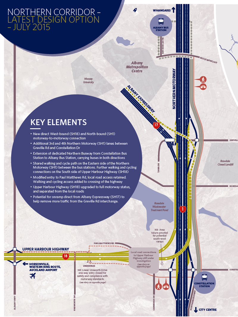
- Motorway bits for cars and trucks (no surprise there)
- An extension of the Northern Busway from Constellation Bus Station to Albany Bus Station (great news for our PT colleagues, as this bit was initially going to be excluded). It would be great if they could drop another bus station in the middle too.
- And on the cycling front, our pleas have been heard…
Firstly, have a look at the map, then we’ll go through the highlights. Click the map to see a higher resolution PDF:
Please can we share the corridor ALONG the motorway sections
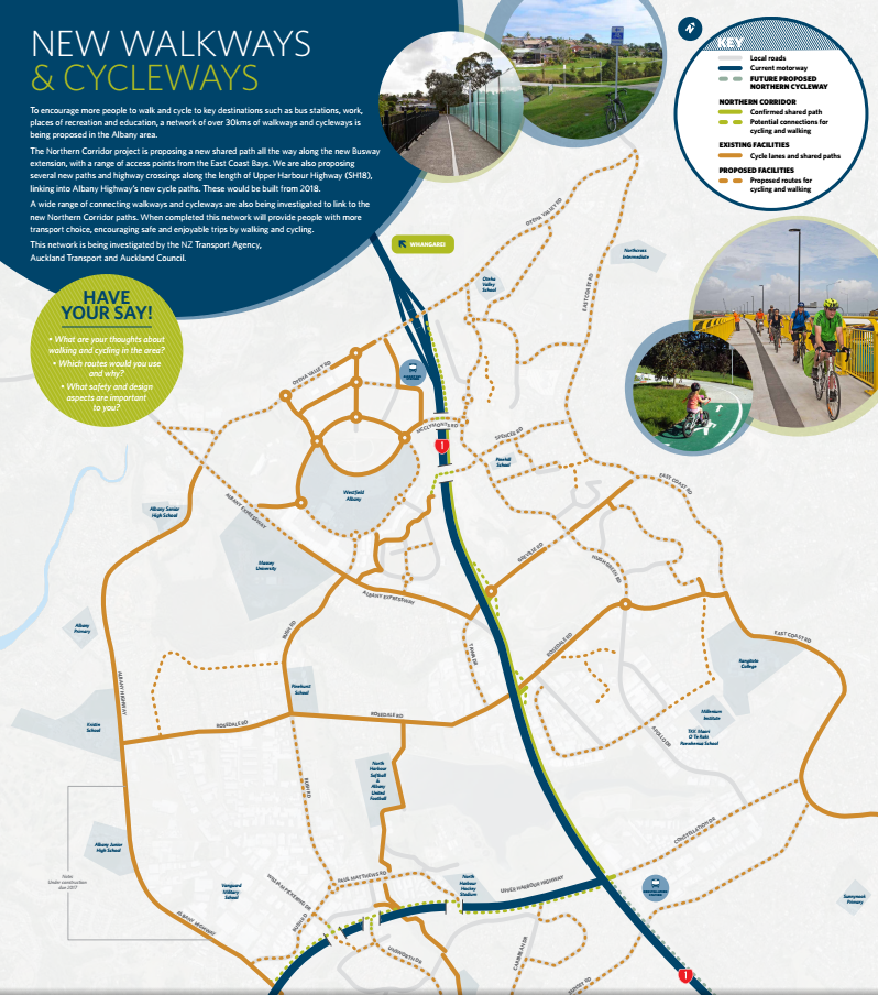
Why yes, you can! Take a look at that solid green line running alongside SH1. That’s a confirmed 5m wide corridor, allowing a 4m shared walking and cycling path. But hang on – some parts are dotted green lines, which according to the key means they’re only “potential” connections. Does that mean they won’t be built? No, not at all. They will be built, but NZTA has to jump through a few more hoops as they don’t have full authority over components of the corridor. As they say,
“The NCI paths in both solid and dotted green form the recommended proposal being put forward by the NZ Transport Agency. The parts shown as dotted are depicted this way only because they fall outside the agency’s current designation, and due process will need to be followed to apply for and receive designation rights before the exact placement can be firmed up“.
So that means we’ll get shared paths along SH1 between Oteha Valley Rd and Constellation Rd, with on/off ramps at Greville & Rosedale Rds, where currently there’s nothing. As for SH18/Upper Harbour Hwy, you’d be a very brave cyclist to attempt to use its narrow shoulders at present with traffic roaring past at 80kph. The shared path will be very welcome there as well, to link up with Albany Highway.
Now, what about that intriguing dotted line heading south along SH1 from Constellation Drive? Does that mean we’re going to get another shared path linking to SeaPath at Esmonde Rd? Well, nothing is cast in stone, and it’s certainly not in scope for this project, but that certainly seems to be the intention. The “Future Proposed Northern Cycleway” running between Oteha Valley Rd in the north to Westhaven cityside in the south via SkyPath. The vision is there!
Please can you provide opportunities for us to CROSS the motorway sections
There’s no doubting the severance effect of any motorway, but a review of the map shows at least some porosity in those heavy blue motorway lines. The link at Greville Rd is particularly welcome, as this is a pretty hostile cycling environment at present.
Please work with Auckland Transport to identify and design routes linking popular origins and destinations for cyclists and tie these in
This is another pleasing aspect of the design. NZTA has been working closely with AT to identify popular destinations, with schools, tertiary institutions, sports facilities, shopping centres and bus stations marked on the map. The ball is now in AT’s court to turn those dotted orange lines to solid ones with good quality linkages. This will take the 5km of committed NZTA paths and add 25km of AT paths – which is where you come in. During the consultation process the NZTA/AT team is going to want the public to help prioritise those paths, so start thinking.
You might also like to identify a route that’s completely missing from the map. For example, Apollo Drive is crying out to be included, particularly due to its proximity to the Millennium Institute and Rangitoto College.
Please design for novice and less confident cyclists
The important thing here is to have some element of physical protection for cyclists. NZTA’s 4m wide shared paths certainly have this, but unfortunately when we get out onto AT’s street network, protection pretty much disappears. A typical example is Rosedale Rd – shown as a connected cycling link from Albany Highway to East Coast Rd, but all cyclists get is a 1.5m wide cycle lane separated from traffic by a line of white paint. Okay, it’s better than nothing, but we can do better now. An extra 600mm would provide for a painted buffer and plastic posts, resulting in a much greater perception of safety for novice cyclists.
Please design for cycling as a transport mode, i.e. direct links
That’s the beauty of motorways – they’re straight. But even the other links shown on the map are reasonably direct. What we don’t want is another Dominion Rd where motorised traffic gets a direct link, but cyclists unwilling to share a bus lane are forced into a meandering zigzag of narrow side streets.
Summary
So all up, well done NZTA and AT. Your first cut looks pretty good, but as we all know, the devil is in the detail. But there’s lots of good stuff in there. A particularly good outcome would be to galvanise AT into bringing forward some of the critical missing connectors on the Auckland Cycle Network. If for example, Albany Highway South is brought forward, we’d have an excellent north/south link to the west (including renovation of the appalling Upper Harbour Drive intersection) coupled with a major east/west link along the SH18 motorway providing access west to the Greenhithe Bridge.
A request to our readers: let us know what you think in the feedback section of this post below. We’ll review your comments and use them to supplement our own formal submission.
Timeline
First step is public feedback closing in mid-September, with detailed design and consents taking us to mid-2016. Construction will be done in stages, with sections completing from 2018 to 2021.
Where to go for more information
Project overview: http://www.nzta.govt.nz/projects/the-western-ring-route/auckland-northern-corridor/
Have your say direct to NZTA (by 5pm Friday 18 September 2015): http://www.nzta.govt.nz/projects/the-western-ring-route/auckland-northern-corridor/have-your-say/


